
Einleitung
LASAT (Lagrange Simulation von Aerosol-Transport) ist ein Modell zur Simulation der Ausbreitung von Schadstoffen in der Atmosphäre. Es wurde beim Ingenieurbüro Janicke entwickelt und kommt in unserem Büro in der jeweils aktuellen Version zum Einsatz (siehe www.janicke.de).
Das Modell ist ein Lagrangesches Ausbreitungsmodell und ist konform mit der Richtlinie VDI 3945, Blatt 3 (Partikelmodell).
Anwendungen
LASAT wird in unserem Büro für Gutachten z. B. bei Verkehrs- und Industrieanlagen, Gerüchen und anderen Schadstoffquellen in zwei Bereichen angewendet. Darunter sind
a.) Typische Fälle (Einzelanwendungen)
b.) Spezialfälle mit Kopplung von anderen Modellen
Zu a.) Beispiele werden im Folgenden aufgeführt:
- Ausbreitungsberechnung mit Zeitreihen unter Beachtung der zeitlichen Korrelation zwischen Emissionen und Meteorologi
- Berücksichtigung von Topografie und Landnutzung z. B. für horizontal variable Depositionsgeschwindigkeiten in Ausbreitungsrechnungen.
Abb. 1 zeigt die Konzentrationsverteilungen entlang von Straßen unter expliziter Berücksichtigung der topografischen Verhältnisse.
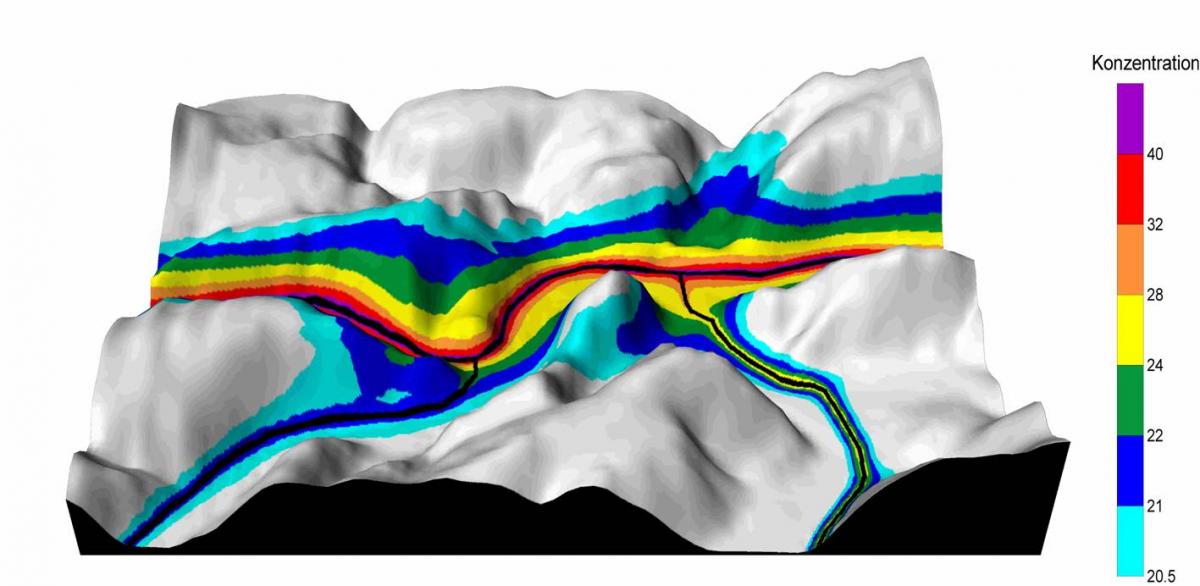
Abb. 1: Konzentrationsfeld mit LASAT berechnet, Topografieeffekt: Schadstofffahnen reichen in Täler ohne Quellen
Die Abb. 2 zeigt ein Beispiel für die flächenhafte Verteilung der Stickstoff-Depositionen (N-Deposition) im Nahbereich einer Straßentrasse.
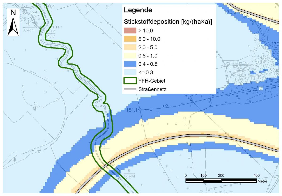
Abb. 2: Mit LASAT berechnete N-Deposition im Nahbereich einer Straße
Zu b.) Beispiele für Spezialfälle mit Kopplungen mit anderen Modellen
- Berücksichtigung von Kaltluft in der Ausbreitungsmodellierung (LASAT/KALM-Kopplung)
- Einbindung externer prognostischer Windfeldbibliotheken [z. B. bei starker Geländeneigung oder Gebäudeumströmung (LASAT/METRAS- oder LASAT/MISKAM-Kopplung)].
Neben der Nutzung von Strömungsfeldern eines internen diagnostischen Strömungsmodells (LPRWND) können in LASAT auch extern berechnete Windfelder integriert werden. Ein Berechnungsbeispiel für eine Ausbreitungsrechnung mit LASAT unter Berücksichtigung von Kaltlufteinflüssen ist in Abb. 3 dargestellt.

Abb. 3: Mit LASAT berechnete Stickstoffdepositionen unter Einbindung von Kaltluftwindfeldern bei der Ausbreitungsrechnung
Zusätzlich kann auch eine Kopplung mit Wind- und Turbulenzfeldern des prognostischen, mikroskaligen Strömungsmodell MISKAM erfolgen. In Abb. 4 ist ein Beispiel gegeben.
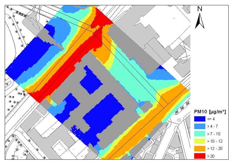
Abb. 4: Ausbreitungsmodellierung mit LASAT mit expliziter Berücksichtigung von Gebäuden unter Nutzung externer Strömungsfelder von MISKAM (Lohmeyer, 2010)
Bei Ausbreitungsrechnungen in stark gegliedertem Gelände wird das Strömungsfeld aus dem prognostischen, mesoskaligen Modell METRAS-PC eingebunden.
Die Verwendung von mit prognostischen Modellen extern berechneten Wind- bzw. Turbolenzfelder in LASAT (bzw. AUSTAL) ergibt höherwertige Immissionsprognosen als die in LASAT standardmäßige diagnostische Windfeldmodellierung.
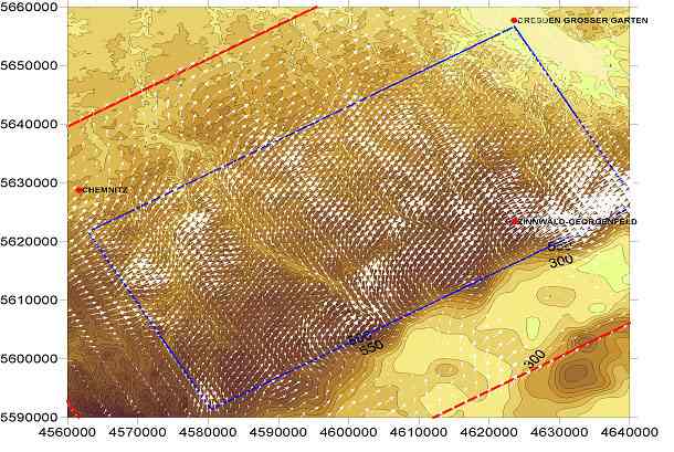
Abb. 5: Mit METRAS-PC berechnetes bodennahes Windfeld für eine Anströmung von 270 Grad mit einem geostrophen Wind von 3 m/s und stabiler Schichtung der Atmosphäre (Lohmeyer, 2004)
Fazit
LASAT ist ein anerkanntes Modell zur Ausbreitungsrechnung von Schadstoffen. In unserem Büro wird es bei fachlich unterschiedlichen Erfordernissen verwendet. Darunter sind typische Einzelanwendungen sowie die Kombinationen mit anderen Modellen im mikro- als auch mesoskaligen Untersuchungsgebieten. Damit werden für jeden fachlichen Anspruch qualitativ hochwertige Ergebnisse erzielt.
Literatur
Lohmeyer (2010): Modellierung der PM10-Konzentrationen inkl. Inhaltsstoffe für die "Schlossparkepisode" im Bereich Stuttgart-Neckartor. Ingenieurbüro Lohmeyer GmbH & Co. KG, Radebeul. Projekt 70566-09-10, November 2010. Gutachten im Auftrag von: Landesanstalt für Umwelt, Messungen und Naturschutz Baden-Württemberg, Karlsruhe.
Lohmeyer (2004): Fachinformationssystem METEOKART GIS, Modul Kaltluft für Teilgebiet "Osterzgebirge". Ingenieurbüro Lohmeyer GmbH & Co. KG, Radebeul. Projekt 70062-03-10. November 2004. Fachbericht im Auftrag von: Sächsisches Landesamt für Umwelt und Geologie, Dresden.
Janicke (2011): Dispersion Model LASAT Version 3.2 Referenz Book. Janicke Consulting, Dunum, August 2011.
Richtlinie VDI 3945, Blatt 3 (2000): Umweltmeteorologie - Atmosphärische Ausbreitungsmodelle - Partikelmodell. September 2000.